Over the years we frequently drove past the inviting narrow country lane off Rosendale Road, a small white sign with black letters announcing its terminus being New York Barge Canal Lock Number Seven. As a child, I remember infrequent visits to the lock to watch the oil barges going through the lock structure; the groaning and metallic creaking of the large steel gates with their patches of rust as they slowly closed at the lower level and then the swirling maelstrom of muddy, polluted Mohawk River water filling the lock until it was in the same plane as the dammed river height. A repetition of the subterranean sounds and the upper gate opened and the tug pushed the barge into the lock, barely fitting into the structure with its burden. Hidden valves operated and the water slowly dropped to the lower level, causing a giddy feeling among the spectators as the aggregation dropped into a manmade concrete cavern. With the lower gate open, the tug, with a mighty churning of water, roared into action and cargo and its propulsion headed downriver.
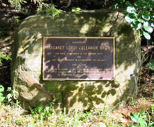
Fascinating entertainment for the child of all ages, but the seasons have passed and the river has changed. Economic factors and transportation fundamentals have virtually eliminated barge traffic and the new “kings-of-the-hill” are private pleasure craft, from small sailing vessels to the most elaborate cruisers. The mysterious small road that led under the “one-way” railroad bridge has also changed. The bridge is gone, an archaic impediment to traffic; replacing it now are paved inclines that are part of a modern phenomenon- the bicycling, running, walking trail that uses an historic railroad right-of-way. These recreational lures are the achievement primarily of two women, Margaret Lordi and Eleanor Brown in June of 1986.
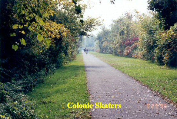
One of the outstanding attractions of this particular trail system is the sublime length: others are shorter or disjointed and require you in many instances to travel on city streets, a practice I would rather not engage in. The local system allows a biker to select short or long routes, each feeling complete and logically fulfilling. My practice, after building up my endurance to seasonal levels, is to either opt for “Schenectady” or “Niskayuna-Colonie”. If it is the latter, I park the car on the Lock #7 access road at the point of intersection with the trail where there is a convenient parking area. Off with the “bungie” cords and the nylon strap, check the odometer to be sure it is reset to “zero”, on the bike and downshift to a lower ratio and up the incline toward the East.
On this particular day in early May, it is cool in the morning requiring a windbreaker and, as the wind caused by the bicycle coming up to speed increases the wind-chill factor, I begin closing the snaps to conserve body heat until my body temperature rises due to the exercise. The trail began life according to the bicycle trail map as a New York Central railroad right-of-way along the South bank of the Mohawk, although I suspect that it was originally the Schenectady and Troy Railroad. There is still faint evidence of its origin: a few mileposts bearing cryptic markings such as “S9”, some old railroad ties rotting away in isolated areas and the quaint, old bay-window freight station near Vly Road. The gradients are usually gentle with a few spots where the fireman must have had to shovel the coal more vigorously; these are where I have to shift the bicycle to a lower ratio to maintain some forward motion! After a short section of woods, there is a grade crossing for a farmer to move his machinery since he has fields on both sides of the path. In season, they are bountiful with luscious harvests of tomatoes and cauliflower but, at this time, the workers are doing the plowing and preparation for planting when there is less chance of frost. A short section of open area continues and then we return to forest on both sides with an occasional tree close enough to the paving to cause ridges in it from the root pressure. Since last year, someone has surgically cut precise areas out of the disturbed blacktop and performed a beautiful job of repair.
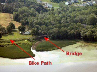
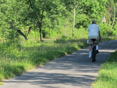
The next landmark is the bridge to Mohawk Island, a lofty steel structure painted in primer red that provides one-way traffic to the camps on the island. It is an ideal spot for fishermen to park and try their luck in the adjacent pond or the fork of the Mohawk that necessitated the construction of the bridge. From this point to the area around the railroad station usually has the most congestion: runners and joggers, hikers, persons walking their dogs and, occasionally, even a roller skater. Most people have the habit of walking on the right side which leaves them facing away from approaching traffic such as myself. It is most peculiar that, in my experience, it is extremely dangerous to quietly try to go around these persons without announcing your presence; just as you pull alongside, they invariably choose that precise instant to move to the other side. My theory, since I have no expertise, is that they subconsciously sense your presence which causes the movement toward your approach. It has happened so often to me, almost invariably, that I now ring my warning bell on each approach to avoid collision.
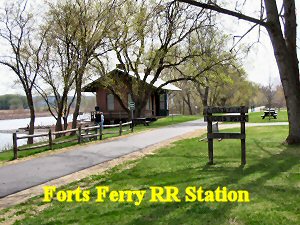
The railroad station with its typical bay-window architecture is the centerpiece of the Lion’s Park at which the fraternal group has provided benches for picnicking and contemplation along one of the river’s most scenic spots. Occasionally, an artist is seen with easel depicting this attractive scene but the majority is resting, reading or relaxing.
Passing around a barrier after the station, the path is quite straight and level with some rotting ties and a wider grading giving evidence of a small yard with sidings for car storage. Going past the Niskayuna water pumping and aeration station with its low ground-hugging tanks, a slight grade starts. To the left a dark, winding path leads through brush and weeds toward the river; opening graciously to an enthralling vista of gloriously blooming water lilies filling the bay off the main channel. Well worth a photo although the day is overcast and a choir of mosquitoes appears to feast on the visitor. The path now becomes a little rough because of plant roots under the blacktop exerting the enormous pressures of growth; it is just a matter of time until the surface will have to be replaced. Following closely along the River Road, the next point of interest is going over the original railroad bridge, whose planks have recently been replaced, which crosses a small stream. The shallow river areas are overgrown with water chestnut with a channel showing the stream’s path. There are frequently fishermen in boats in this area (the fishing must be good) and this special scenic area also has benches for the weary or contemplative. Residents with this spectacular view of the river’s bend mow the area meticulously so that it is very attractive.
A short distance and we come to a barrier revealing the Forts Ferry Road crossing. Carefully observing traffic, we cross and go around the opposite barrier and continue through a dense wooded section leading to another barrier controlling access of the road to the Colonie water pumping station. Another short section of woods and we come to the Colonie “pollution control” installation on our left which processes the sewage before allowing the effluent to enter the Mohawk River. On the right, in the distance, is a curiously raw landscape of eroded hills. It is the remains of a borrow pit for sand and gravel whose sandy tracks are occasionally travelled by a lone truck. Also on the same side are asphalt-coated holding basins- presumably to hold overflows but being used to hold the raw wood-chips and wood-chip sludge mixture that is the final result of processing. After dankly, odorously steaming in the cool summer mornings with the heat of decay, the ultimately decomposed humus becomes host to weed seeds, unfortunately mostly ragweed, and grows a luxuriant cover of green. On a slight curve to the left, the trail shows a shiny blackness in the paving betraying its newness due to a sewage main, with periodic manhole covers in evidence, having been installed to service the growing Colonie district.
A fill across a ravine gives a view of the Hudson in seasons when the deciduous trees have shed their leaves, otherwise the vista is the same as the other side- trees on the steep slopes and a tiny stream at the bottom. The following hills were cut to moderate the grade of the route for the trains of history. A large North-South high-voltage transmission line crosses with sand drawn across the bisecting bicycle path by occasional children on all-terrain vehicles chasing along the power line access route. The wilderness on the South contains, in the Spring, beautiful groups of dark red Trilliums with their triple leaves and petals and the white Anemone or “wind-flower”. Present in large numbers are May-apples with their umbrella-like leaf pattern.
Open to the left, a sharp drop reveals a small, somewhat sandy settlement of summer homes and regular residents on the shore of the near-by river. A small distance further up a gradually increasing grade through a small patch of woods and we come to the highest point of the trail, forced to a sharp turn to the North because of the Northway bisecting the railroad right-of-way. Down a very steep incline and we are on a blacktop road in the community on the Mohawk River previously seen from the heights.
This original essay was written many years ago: How many I can only estimate since I have had several computers, including a "fat Mac" in the beginning. "Properties" gives a date of April 2003 but I suspect it was much earlier. I have left it pretty much untouched, but unfinished. Herewith is "the rest of the story".
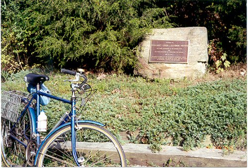
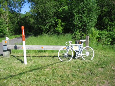
In 1988, two years before my early retirement (unsuspected at the time), I purchased a bicycle at the Sears store in Colonie Center. I had seen Sears newspaper ad touting their "Free Spirit" bicycle for $100! (the blue bike in the first photo above at the Lordi-Brown monument on the path at Lock 7). It was a great price and had the features I was looking for - not a racing style bike with dropped handlebars and with reasonable mid-size tires. I brought it home in its box and assembled the machine. It was a partnership that would last for twelve years and quite a few tires. I bought a trunk-lid carrier at Plane Boys for my MercuryMarquis and went to the bike trail in Rotterdam at Lock 8. You will note that the path was completed in 1986 (on the monument to Margaret Lordi and Eleanor Brown) so it was very new. I timidly found I could still ride a bike after 30 years and enjoyed the exercise on weekends until retirement in 1990.
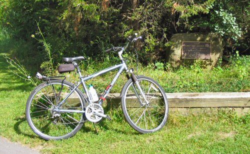
The marvelous Trek bicycle gifted to me on my 70th birthday by Randy and Bobbi, Russ and Kris. It is a joy to ride (a comfort style with shock-absorbing fork and seat). I have a fabulous "Cat-Eye" speedometer and odometer on the handlebars. It doesn't seem possible that I have been riding it for eight years.
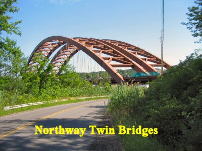
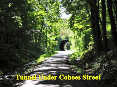
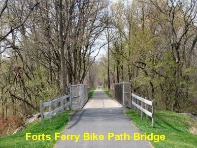
To continue: As I pedal along the road it turns left and you can see the NYS Northway beyond an empty lot with a fence along the express road. Down a slight grade takes you under the twin bridges that take the road over the Mohawk. Back up a grade, passing several houses, you come to a "T" intersection. The bike path sign indicates a turn to the right. It is quite steep so I get off and push the bike about halfway up the grade. Then back on and across the road at the stately old train station which is now an attractive home. Around the post barrier and you are on a long straight stretch of paved path. It ends in a path parking lot accessed from a road crossing the path - with Colonie's 160 acre Town Park across the road and on the left of the bike path. They have several ball fields and swimming pools for town residents. The last time I was on this section of the path it was unpaved. The surface was clay and possibly stone dust, a nice hard surface for biking. It was paved in 2006 so this time I enjoyed the new blacktop surface. Past the complex and through a small woods you come to an underpass tunnel. It goes under Route 9, a major north-south road. Past the tunnel on the right is a large crushed stone, concrete facility with lots of large trucks that cross the path to a side road to Route 9. With homes on the left you pedal quite a distance to a downward slope with a large municipal housing complex on the left, the path leading to a stop sign at a road crossing. If you go to the left a short distance you will see the famed Cohoes Falls of the Mohawk River. Continuing downward we find ourselves in a small Cohoes park and another tunnel under a city street. Through woods, into the outskirts of Cohoes and, to the right, more woods with two bridges over city streets. The second is over Columbia Street, a major thorofare. Then in the woods on a hillside with city homes on the left. This section of the bike path then ends, as it always has, at Alexander Street in Cohoes.
The photo on the left was taken on May 19, 2010. The aerial photo on the right was taken on a return flight from Barnes, MA on April 22, 2005.
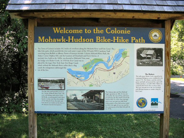
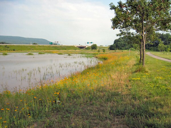
The left-hand photo shows the sign depicting the bike trail in Colonie. It is situated in a small park on the River just over the Niskayuna line going East. The right-hand photo is from the Rotterdam trail showing the entrance to Exit 26 of the NY Thruway in the distance. It is of a wet land converted from a grassy meadow by State employees to replace a wet land displaced by the re-building of the Latham Exit 16 of the Northway. They appear to have been successful - the pond has fish and I have seen numerous bluebirds, the New York State Official Bird. It is now a favorite haunt of our numerous Canada geese.
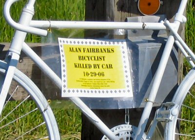
The most dangerous crossing on the bike path, in my opinion, is in Rotterdam Junction where you have to cross Route 5S. There is a curve in the road just before the crossing so you have to look back (to the left going West). Road posted speed goes from 55 to 40 (easily overlooked) just short of the crossing. A few years ago the brush along the road obscured your view and I, myself, had a very close call with a crushed-stone truck barreling along to Rotterdam Junction. A friend, Tony Durante, who walked the bike path, complained to the Highway Department several times before they finally cut down the brush to extend our line-of-sight. Evidenced by the memorial, Alan Fairbanks was not so lucky and his biking club posted this memorial to his memory (along with explanatory flyers since removed). Nonetheless, our Mohawk-Hudson Bikeway is a uniquely rare asset which I have cherished for the last 20 years.
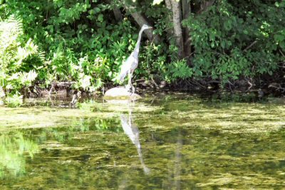
Photos taken on July 15, 2011 on the old Erie Canal in Rotterdam Junction. I have tried for some time to photograph the extremely shy, reclusive herons on the Mohawk. On this day luck was with me and I had my new Canon G12 camera (my previous "point-and-shoot" was giving me fuzzy pictures). In the first picture the heron was partially hidden in the grass (having taken flight on my approach on the path). As I was attempting to take a picture of the heron's exposed neck a biker went around me and the bird took off (between the trees on the left). Didn't know I had caught the bird in flight until later. Continuing, I spotted him on the further bank - used my cameras 5x zoom - and here is the happy result!

Original: Probably in the early 1990's. Converted to HTML and updated: August 30, 2008; September 18, 2008; August 17, 2010.
Added photos: 9-6-2008, 8-17-2010. Heron pictures - July 19, 2011.